Trevor Reginald Nossiter (1906-1992)
Senior Reconnaissance Officer, Weapons Research Establishment 1954-1969
By Laurie McLean March 2022
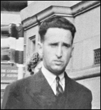
Trevor Nossiter circa 1942.
RAAF service record image from National Archives of Australia.
Between July 1954 and August 1969 Trevor Nossiter was employed by the Long Range Weapons Establishment as the Senior Reconnaissance Officer in the Research and Development Branch (initially based at Salisbury in South Australia and later in Western Australia).
Upon taking up that newly created position, Trevor was responsible to the Chief Superintendent, Long Range Weapons Establishment, for the planning of the civil construction and the maintenance of installations beyond the immediate range head area (ie Woomera). Trevor’s work involved planning, directing and, at times, leading necessary reconnaissance journeys as the range was pushed further into Australia’s interior. Trevor was the Officer-in-Charge of the Engineering Reconnaissance Section at the Weapons Research Establishment. Some background highlights on the Weapons Research Establishment are provided at Appendix A.
Interaction between Nat Map and Weapons Research Establishment
Between the late 1940s and the mid-1970s there was a high level of collaboration and cooperation between the Long Range Weapons Establishment (Weapons Research Establishment from 1955) and the Division of National Mapping. In his 1979 paper The Division of National Mapping’s Part in the Geodetic Survey of Australia, Nat Map’s Senior Technical Officer Reg Ford BEM (1914-1994) listed some of the assistance WRE provided to Nat Map during national geodetic survey operations; details of this assistance are provided at Appendix B.
By 1958 the Weapons Research Establishment had advised Nat Map that it required to be completed by the end of 1959 some 4 350 kilometres of geodetic traverse loop (by theodolite and Tellurometer), namely: Alice Springs - Finke - Giles ‑ Rawlinson Range - Roy Hill ‑ Derby - Halls Creek - Alice Springs. This survey traverse was to provide the required control at the Talgarno dump area (between Broome and Port Hedland) in time for the firing of the Blue Streak rocket in 1960. Of the 4 350 kilometres of traverse required, Nat Map had completed approximately 1 800 kilometres during 1957 and 1958.
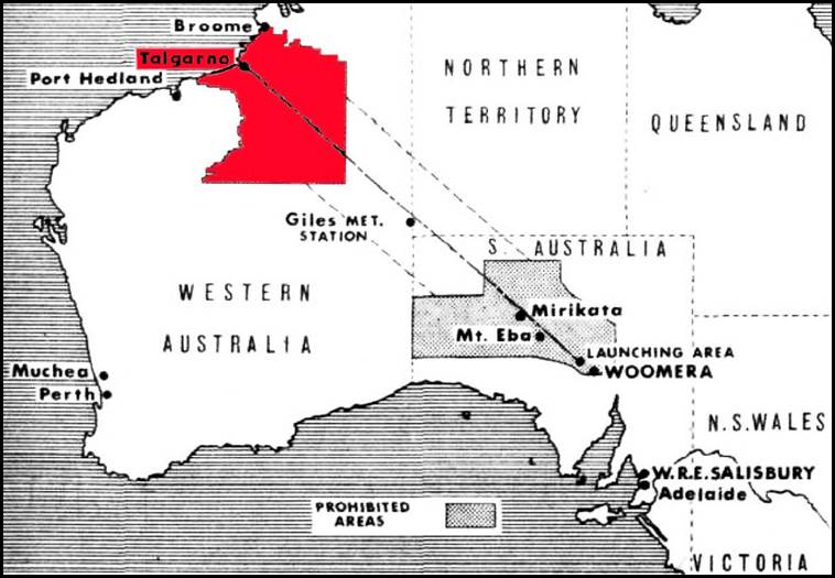
Map of the WRE prohibited areas at the Woomera Range and the Talgarno Blue Streak dump area.
The 1959 field survey program required Nat Map to complete a further 1 800 kilometres of geodetic traverse. This survey traverse work was in two sections. Firstly from Mt Hinckley (in Western Australia just south of the South Australia–Northern Territory border) to Carnegie homestead and from there north of Wiluna and on to Roy Hill. The second section ran from Mt Anderson (overlooking the Fitzroy River about 120 kilometres south-east of Derby) to Halls Creek. Owing to the tight timeline for the overall traverse loop to be completed, the Western Australian Department of Lands completed about 720 kilometres of geodetic traverse between Roy Hill and Mt Anderson.
Prior to the southern Western Australia section of the geodetic survey being undertaken, an aerial reconnaissance of the traverse route area was undertaken. On 26 and 27 September 1957, Bruce Lambert (Director of National Mapping) and Trevor Nossiter (Senior Reconnaissance Officer, Weapons Research Establishment) carried out the aerial reconnaissance; roughly along the 26° South parallel of latitude. Their purpose was to investigate the possibility of taking geodetic control by theodolite and Tellurometer traverse from near the Northern Territory - South Australia - Western Australia borders junction to the Carnarvon Range (west of Wells 5 and 6 on the Canning Stock Route north of Wiluna) in Western Australia. This aerial reconnaissance yielded a favourable report. As mentioned, the proposed geodetic survey was to supply early control into Broome for the Woomera Range (and the future Talgarno Blue Streak rocket dump area on Anna Plains Station). The survey was also needed as a valuable link in the main geodetic survey scheme covering Australia.
After the 1957 aerial reconnaissance, arrangements were made for Nat Map and Weapons Research Establishment personnel to undertake a ground reconnaissance and select sites for the survey traverse stations. The ground reconnaissance was undertaken in May 1958, see below. The ground party also inspected the traverse route for a possible graded track as a supply line. The survey station access and supply track which later took on the name as the third stage of the Gunbarrel Highway was completed between September and November 1958 by a Weapons Research Establishment road construction party led by Len Beadell. The earlier stages of the Gunbarrel Highway which commenced in 1955 ran from Victory Downs just west of the Stuart Highway in the southern Northern Territory to the site of the Giles Weather Station and then south-west past Lake Christopher to the so called Jackie Junction (near Mt Harvest to the north of the then Warburton Mission). The mission closed in 1977 and is now the Warburton Ranges Mirlirrtjarra Community.
Gunbarrel Highway reconnaissance 1958
During 14-28 May 1958, Nat Map Senior Surveyor Howard Angas (Bill) Johnson MBE (1907-1990) carried out a ground reconnaissance from Mt Harvest (near Warburton Mission) in Western Australia to Mt Bates near Carnegie Homestead, about 480 kilometres to the west. Bill Johnson was accompanied by the Weapons Research Establishment’s Trevor Reginald Nossiter (officer-in-charge Engineering Reconnaissance Section), Leonard Beadell (range reconnaissance officer), Walter Batchelor MacDougall (1907‑1976) (native patrol officer) and an R Smith (WRE mechanic).
As mentioned above, in late 1958 a WRE field party under Len Beadell undertook the necessary track clearing for what was later part of the so called Gunbarrel Highway along the route chosen by the Johnson-Nossiter reconnaissance party.
In 1959, a geodetic survey party under Nat Map’s Reg Ford erected survey station beacons along the 1958 reconnaissance route and undertook theodolite traverse observations as part of the survey to meet Nat Map’s and WRE’s (Blue Streak) requirements. Reg Ford’s survey party comprised 9 people including 5 Field Assistants from WRE. Nat Map’s Reg Ford and Gerry Cruickshanks were the only observers. A separate Nat Map field party under surveyor Malcom Albert Nicholas carried out distance measurements along this traverse using Tellurometers. The route of the 1958 reconnaissance and the 1959 survey stations is shown on the map below.
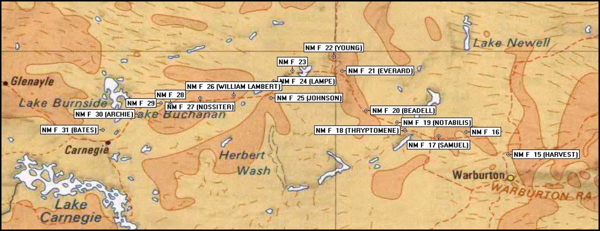
Route of the 1958 Gunbarrel Highway reconnaissance with 1959 survey station locations. Base map annotated by Paul Wise.
Feature names
As a result of the ground reconnaissance in May 1958 for the geodetic survey traverse route, several features along the Gunbarrel Highway were named for reconnaissance party members, namely: Trevor Nossiter, Bill Johnson, and Len Beadell. In addition, Mount William Lambert was named for William John Lambert (1882-1956) who was the late father of Bruce Lambert, the Director of National Mapping. As shown in the table below, geodetic survey control stations were established on these features in 1959.
|
Feature name |
Coordinates |
Survey station No |
|
Mount Nossiter |
25° 25’S 123° 47’E |
NM/F/27 |
|
Mount Johnson |
25° 25’S 124° 25’E |
NM/F/25 |
|
Mount Beadell |
25° 32’S 125° 17’E |
NM/F/20 |
|
Mount William Lambert |
25° 24’S 124° 05’E |
NM/F/26 |
Features named for people associated with the 1958 ground reconnaissance party.
Working at Talgarno
A base and associated accommodation village was established at Talgarno in 1960 for the Blue Streak rocket program. Talgarno was about 170 kilometres south-west of Broome in Western Australia. The village was built on land excised from Anna Plains Station and was immediately east of Anna Plains homestead; the village was decommissioned by September 1964. (Later, some of the buildings from Talgarno were used for the Willare Bridge Roadhouse on the bank of the Fitzroy River east of Broome, others went to Derby.) Trevor Nossiter was involved in establishing the base and village at Talgarno. Nat Map’s Reg Ford visited Trevor Nossiter at Talgarno circa early October 1959 to discuss progress with geodetic survey operations (Ford, 1979).
Some Nossiter family details
Trevor Reginald Nossiter was born at Hobart on 17 February 1906. He was the third of the five children born to William Henry Nossiter (1878-1943) and his first wife Edith Kate (Kate) Nossiter née Gilham (1883-1911) who was born in Victoria. William and Kate were married at North Hobart on 15 November 1900. Their 5 children were: Edith Beryl Maida (Beryl) (1901-1984), William Edward Athol (Athol) (1903-1996), Trevor Reginald (1906-1992), Nancy Alberta (1909‑1990) and Fredrick Harold (1911-1911).
Trevor’s mother Kate Nossiter died in Hobart on 14 May 1911 when Trevor was just five years old. His mother’s death occurred 9 days after her fifth child Fredrick was born; sadly the infant died on 26 July 1911.
At Hobart in 1912, Trevor’s widowed father William married Mary Ann Louise (Louise) Rolando (1880‑1944) who was born in Hobart. Later, William and Louise Nossiter had 2 children. On a 1919 electoral roll William and Louise Nossiter were listed as residing at 74 Invermay Road Launceston as engine driver and home duties, respectively.
Early Schooling
Trevor Nossiter attended the Invermay State School (in a northern suburb of Launceston). In examinations held on 27 November 1917, Trevor qualified to attend the Launceston State High School in 1918 (Anonymous, 1918). Now known as Invermay Primary School, the Invermay State School was established in 1889.
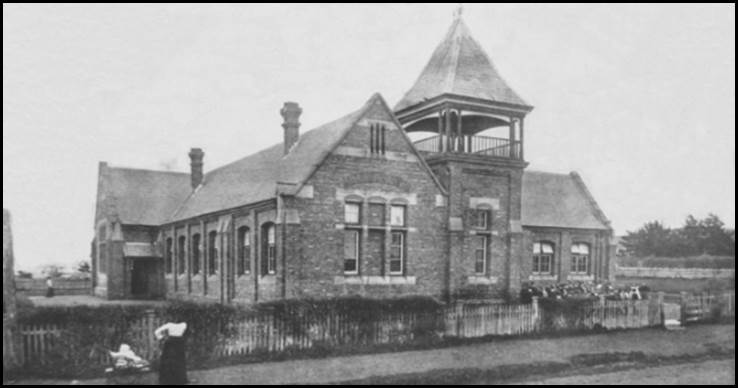
Invermay State School in its early days.
Edited image from Invermay Primary School web site.
Marriage of Trevor Nossiter and Nellie Manallack 1934
In Victoria on 21 September 1934, Trevor Nossiter married Nellie (Nell) Manallack of Melbourne who was born at Preston, Victoria on 11 September 1903. Nell was the youngest of the 5 children born to Thomas Johnathon Manallack (1861‑1942) and his wife Maryan (May) Manallack née McKenzie (1862‑1926). Trevor and Nell were to have 4 children including daughter Marilyn born in 1935 and son Ronald Gilham born in 1940.
Trevor Nossiter’s early employment
State Rivers and Water Supply Commission of Victoria 1925-1934
Trevor Nossiter worked on various water-related projects with the State Rivers and Water Supply Commission of Victoria from 1925 until 1934.
In 1925 when aged 19 years Trevor Nossiter was engaged as a field assistant with the State Rivers and Water Supply Commission of Victoria. The Commission had wide ranging responsibilities for water supply and distribution in rural and regional Victoria. It was constituted on 1 May 1906 under the Water Act 1905. This Act effectively nationalised all rivers and river frontages in Victoria with these state rivers being vested under the control of the Crown. (An exception was those river frontages purchased prior to 1905.) The SRWSC also brought together all other existing Victorian rural water trusts and irrigation schemes (except for the First Mildura Irrigation Trust which remained in existence until 2008). The SRWSC was replaced by a Rural Water Commission in 1984.
An electoral roll entry for 1931 indicated that Trevor Nossiter was then residing at Huon in Victoria’s north-east and was employed as a chainman; presumably with the State Rivers and Water Supply Commission. Today, Huon is a locality on the Murray Valley Highway abutting the shore of Lake Hume about 25 kilometres south-east of the rural city of Wodonga.
Huon had a goods rail service from 1887 until 1978 and a passenger rail service during some of that period. In 1887 the first section of the railway line that eventually connected Wodonga to Cudgewa was built as far as Huon (the station was initially called Huon Lane). The line was extended to Old Tallangatta by 1891, to Shelley by 1916 and to Cudgewa by 1921. The last train ran on the line in 1978 and it was closed in 1981. The Hume Dam across the River Murray downstream from the junction with the Mitta Mitta River was constructed between 1919 and 1936. In 1922, a spur line was opened connecting Ebden to the Hume Dam construction site to service the work requirements. (Ebden is about 15 kilometres north-west of Huon.)
Between 1935 and 1936, Trevor Nossiter worked in a partnership as a surveyor with Henry Vincent (Jim) Le Poer Trench (1905-1995). Jim Trench was the only child of Ballarat-born engineer Henry Frederick Le Poer Trench (1867‑1938) and his wife Alice Bunter Le Poer Trench née Stokes (1865-1938), they resided in Noel Street Ivanhoe, Victoria.
Jim Trench was a surveyor and civil engineer and a member of the Victorian Institution of Surveyors. Jim was educated to Leaving Certificate level. He was registered as a licensed surveyor by the Surveyors Board of Victoria on 20 October 1931 and was later registered as a surveyor in New South Wales. He was also qualified as a local government engineer in New South Wales.
Jim Trench joined Gutteridge, Haskins and Davey in 1937 and initially worked as a surveyor on a sewerage project for the Maryborough City Council in Queensland. He helped build the survey section of GH&D into one of Australia’s largest survey practices.
In 1937, Trevor Nossiter worked as a computing draughtsman and engineering surveyor with Gutteridge, Haskins and Davey, consulting chartered civil engineers. (The practice of Alan Gordon Gutteridge merged with that of Gerald Haskins and Geoffrey Davey to form GH&D in 1939. Gutteridge (1892-1942) was an expert in water and sewerage related engineering. Gordon Gutteridge held a Master of Civil Engineering (Melbourne) and a Master of Science (Harvard) and was a Member of the Institution of Civil Engineers (London) and a Member of the Institution of Engineers, Australia.
Service with Gutteridge, Haskins and Davey 1938-1942
Initially, in 1938 Trevor Nossiter worked as a designing engineer on a sewerage project for the Ipswich City Council. From later in 1938 until his RAAF enlistment in June 1942, Trevor Nossiter worked as an engineer and surveyor with Gutteridge, Haskins and Davey. During that period he was engaged on various works in Queensland, New South Wales, Victoria and Tasmania.
Work on the Berriquin Irrigation Scheme in the early 1940s
On one project from at least early in 1940, Trevor Nossiter was the resident surveyor and engineer for GHD at Berrigan in the southern Riverina. Here he worked in conjunction with Jim Trench on contour surveys, irrigation channel design, plan preparation and the arranging of excavation works. A series of advertisements for Gutteridge, Haskins and Davey and for Jim Trench and Trevor Nossiter’s surveying services appeared in the Cobram Courier newspaper during the late 1930s and early 1940s; see facsimile below.
|
A. Gordon Gutteridge and Haskins and Davey In Association with H. V. Trench, M.V.LS., Licensed Surveyor TITLE, IRRIGATION AND GENERAL SURVEYORS --------------------- Consulting Chartered Civil Engineers. Grading Experts and Implements Available on Contract or Daily Basis. Contour Surveys Executed Designs and Plans Prepared. T. R. NOSSITER. Phone 100 Resident Surveyor and Engineer BERRIGAN. Local Agent: G. Anderson
|
Facsimile of advertisement from page 3 of the Cobram Courier on 26 February 1941.

Canal excavation work on the Berriquin Irrigation Scheme in June 1940.
(Enhanced) image from Murray Irrigation web site.
Between 1933 and 1964 the New South Wales government developed the state’s largest irrigation network fed by the waters of the River Murray. Construction of the Yarrawonga Weir on the River Murray began in 1935 and was completed in 1939. From the resultant Lake Mulwala storage, water was drawn from the Murray through Mulwala Canal to provide a reliable source of water to a region regularly devastated by drought.
The Mulwala Canal stretches for some 156 kilometres to the north-west from Lake Mulwala, to Finley and then across the Edwards River at the Lawson Syphon just south of Deniliquin. It then continues in a generally north-westerly direction to cross the Wakool River at the Wakool Weir and onwards to terminate at Yarrakool Creek; see map below. It is the longest irrigation canal in Australia. This canal was dug between 1935 and 1942. As well as water for agriculture, the canal provides water for the southern Riverina towns of Berrigan, Finley, Bunnaloo and Wakool.
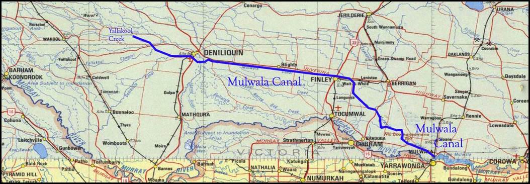
Map of the Mulwala Canal. Base map annotated by Paul Wise.
The first water in the Berriquin Irrigation District was officially delivered near Finley in April 1939. The Berrigan Channel branches off the Mulwala Canal about 14 kilometres south-west of the Berrigan town centre. This channel feeds irrigation water to properties in the Berrigan district through an extensive network of channels.
In 1995 control and operation of the irrigation system was handed from the New South Wales government to the irrigators it served, through the formation of the unlisted public company Murray Irrigation Limited.
With Gutteridge, Haskins and Davey in Tasmania 1942
Immediately prior to enlisting in the Royal Australian Air Force in June 1942, Trevor Nossiter was the engineer-in-charge of the Tasmanian activities of Gutteridge, Haskins and Davey. His then postal address was 95 Macquarie Street Hobart.
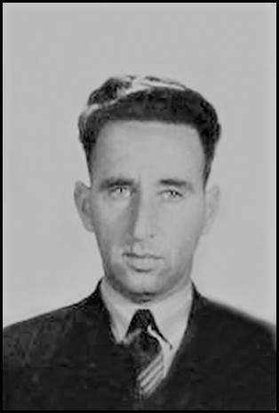
Trevor Nossiter circa 1942.
Enhanced RAAF service record image from National Archives of Australia.
World War II Service with the Royal Australian Air Force
On 8 June 1942, Trevor Nossiter enlisted as a trainee officer (initially, Aircraftman Class 1) in the Royal Australian Air Force at Melbourne; service number 256164. He was then 36 years of age. On enlistment in the RAAF Trevor stated that he was a surveyor by profession and as an associate member of the Victorian Institution of Surveyors. He was also skilled in engineering and in drafting. Initially, he served in the RAAF Administrative Branch, Engineers and later in the Administrative and Special Duties Branch (Works Section).
Trevor served in the RAAF (Citizen Air Force) until discharged on 9 April 1946. At discharge Nossiter held the rank of Squadron Leader and was posted with the No 14 Airfield Construction Squadron. During his time in the RAAF, Trevor served in various postings including the RAAF Staff School at Mt Martha, in the Northern Territory, in the Kimberley Region of Western Australia and at Morotai then in the North Moluccas bordering the Pacific Ocean and the Halmahera Sea.
Trevor Nossiter also had brief assignments at the Richmond RAAF base (August 1943), Fenton airfield, about 140 kilometres south-east of Darwin (December 1943), and at Batchelor in the Northern Territory (in February and in April 1944). A summary of Trevor Nossiter’s RAAF service is provided at Appendix C.
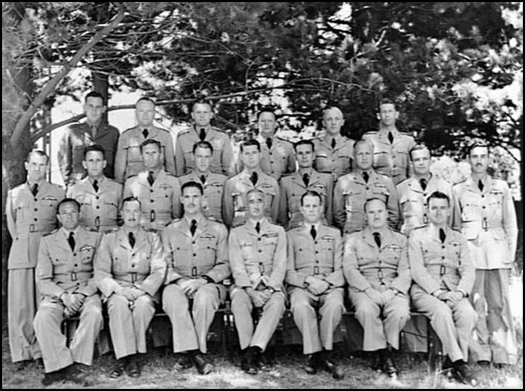
Mt Martha, Victoria 1943. Group portrait of directing staff and students of No 6 War Staff Course at the RAAF Staff School. Back row, left to right: Lt (Sir) David Derham (KBE CMG MBE), AIF; Flt Lt AB Bertie; Flt Lt GK Taylor, Royal New Zealand Air Force; Sqn Ldr S Rose; Sqn Ldr L Strudwick; Flt Lt HG Hiller. Middle row: Sqn Ldr DG Buckley; Flt Lt Trevor Reginald Nossiter; Wg Cdr EV Lansell; Flt Lt JS Mercer DFC; Sqn Ldr DC Pfeiffer; Flt Lt VE Townsend DFC; Wg Cdr RS Rice; Flt Lt CT Scully; Sqn Ldr VF Sullivan. Front row: Gp Capt JA Cohen DFC; Wg Cdr GV Candy; Wg Cdr DLG (Des) Douglas OBE DFC, the unit Commanding Officer; Air Vice Marshal William Hopton (Hawkeye) Anderson, the school commandant; Gp Capt EB Courtney; Gp Capt Ian Dugald McLachlan DFC; and Wg Cdr J Dowling. Australian War Memorial image donated by P Odlam; accession no P02352.004.
No 14 Airfield Construction Squadron
Airfield Construction Squadrons were the RAAF equivalent of Army Engineers, with a primary task of constructing and maintaining forward operating bases for RAAF aircraft. They were raised from 1942 following the entry of Japan into the war. It was immediately evident that there was a paucity of airstrips across the South-West Pacific Area to support air operations.
The No 14 Airfield Construction Squadron was formed within the No 61 Works Wing (Airfield Construction) as No 14 Mobile Works Squadron on 20 July 1943. The Squadron was formed by splitting No 1 Mobile Works Squadron into two units. It was re-formed at Ransford in Victoria 5 January 1944. (RAAF Ransford was the name given to the Melbourne Cricket Ground that became the home of RAAF No 1 School of Technical Training from November 1942.) No 14 Mobile Works Squadron operated from Coomalie (near Batchelor) and Winnellie (at Darwin) in March 1944 before moving to Truscott Airstrip in Western Australia by May 1944.
Truscottt Airstrip Western Australia May 1944
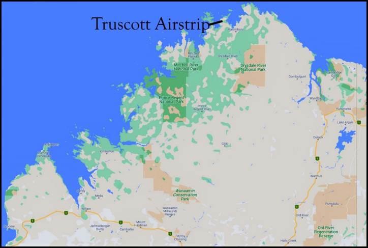
Location of Truscott Airstrip in the Kimberley region of Westen Australia.
Google map image annotated by Paul Wise.
Located about 520 kilometres west-south-west of Darwin and about 620 kilometres north-east of Broome, Truscott Airstrip was on the Anjo Peninsula of Western Australia’s far-north Kimberley coast. It was constructed from mid-1944 by the No 14 Airfield Construction Squadron RAAF under Commanding Officer Squadron Leader Trevor Nossiter.
Truscott Airstrip comprised a single runway of about 8 000 feet (about 2 440 metres) in length and 120 feet (about 37 metres) wide that was surfaced by marsden matting (inter‑locking perforated steel planking). There were extensive dispersal loops at each end of the runway.
As an RAAF base Truscott was actively used during World War II by various aircraft types including Liberator, Mitchell, Anson, Ventura, Catalina and Mosquito. Some graphical information on Truscott Airstrip is provided at Appendix D.
RAAF Truscott was named after Australian ace fighter pilot and VFL footballer, Squadron Leader Keith William Bluey Truscott DFC and Bar (1916‑1943) who was killed on 28 March 1943 in a training accident at Exmouth Gulf on the far-western tip of Western Australia. Truscott’s Curtiss P‑40E Kittyhawk single-seat fighter aircraft crashed into the sea.
Also called Truscott Airfield and Truscott Airbase, the facility is on the land of the Wunambal Gaambera people whose traditional name for the area is Mungalalu. The facility continues to operate today as the Truscott-Mungalalu Airport to service oil and gas operations in the Timor Sea and local needs including the Royal Flying Doctor Service.
Morotai Island September 1944
On 15 September 1944, No 14 Airfield Construction Squadron landed on Morotai Island in the then Halmahera Islands of the Netherlands East Indies, now Indonesia; see location map below.
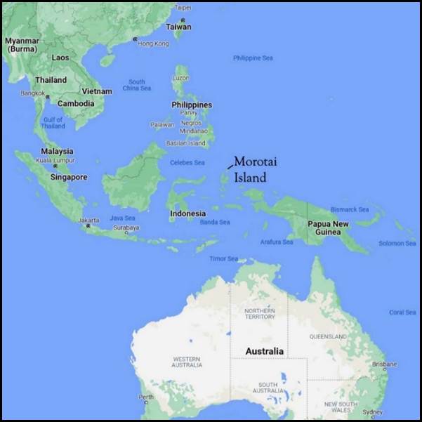
Location of Morotai Island.
Google map annotated by Paul Wise.
On Morotai, No 14 Airfield Construction Squadron worked with the United States Army Engineers to construct the Wama Airstrip, the first of several airstrips built at the south-western end of the island. One of the many construction tasks of No 14 Airfield Construction Squadron was to remove some 4.2 million cubic feet (about 120 000 cubic metres) of coral to provide surfaces for airstrips, runways and dispersal areas for RAAF and United States aircraft as well as for roads. The location of Wama Airstrip is shown in the diagram below.
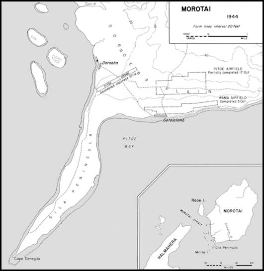
Location of Wama Airstrip on Morotai Island.
Edited version of Map 20 from Smith (1953).
Squadron Leader Trevor Nossiter was in charge of No 14 Airfield Construction Squadron on Morotai. He arrived at Morotai circa 19 August 1944 and, after working there for over 4 months, departed for Melbourne where he arrived on 6 January 1945.
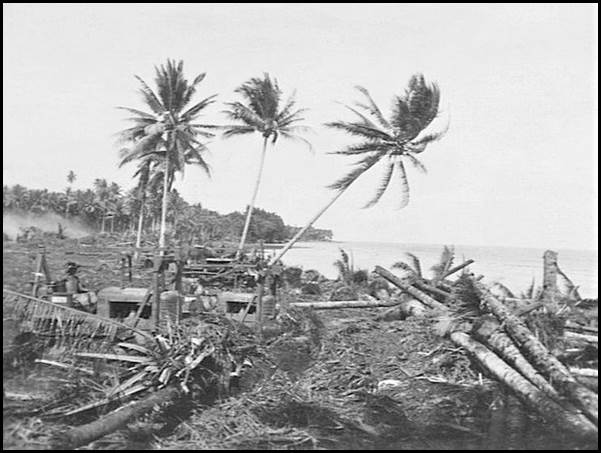
No 14 Airfield Construction Squadron RAAF bulldozers knocking over coconut palms to clear a site for the airstrip on Morotai Island on 19 September 1944. Image by Thomas John Harrison AWM accession number OG1679.
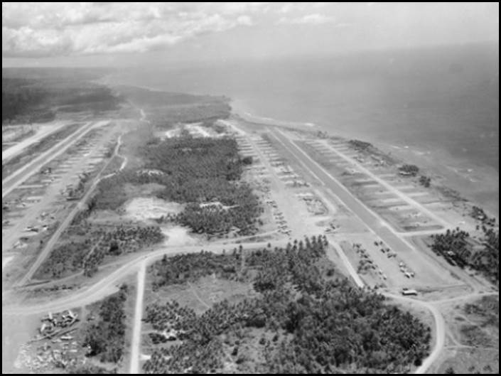
Aerial view of Wama Airstrip at Morotai April 1945.
(Edited) John Thomas Harrison image from Australian War Memorial Accession Number OG1934.
Commonwealth Department of Works 1947-1954
Between September 1947 and September 1954, Trevor Nossiter was engaged by the Commonwealth Department of Works as an engineer. On 18 September 1947, Trevor was appointed as an Engineer Grade 2 (Third Division) in the then Department of Works and Housing’s Engineering Division, Head Office in Melbourne.
Around that time, as well as housing matters the Department’s responsibilities included: the investigation, planning and development of such works of national importance as were referred to the Department by the Commonwealth government; and submissions to the Defence Services of works proposals or work plans (other than Defence Works) for which the Commonwealth was wholly or partially responsible, and which, in the consideration of the Department, had strategic importance.
On 28 April 1948, Trevor was promoted to Engineer, Grade 3 (Third Division) in a newly created position with the Department of Works and Housing’s, Engineering Section in Melbourne. In this position Trevor was responsible for the production of completed designs and drawings for civil aviation projects and the supervision of staff engaged on same.
Electoral roll entries for 1949 and 1954 indicated that Trevor and Nell Nossiter resided at 19 The Grove Coburg. Trevor’s then occupation was engineer and Nell was engaged in home duties.
In 1950, some of the housing functions of the Department of Works and Housing were transferred to the Department of National Development. In 1952, a new Department of Works was created taking the place of the former Department of Works and Housing.
Long Range Weapons Establishment 1954-1969
On 1 July 1954 Trevor Nossiter was promoted to the newly created position of Senior Reconnaissance Officer (Third Division) within the Department of Supply’s Research and Development Branch in the then Long Range Weapons Establishment at Salisbury on Adelaide’s north-western outskirts. In this position Trevor was responsible to the Chief Superintendent of the Long Range Weapons Establishment for the planning of the civil construction and maintenance of installations beyond the immediate range head area. These responsibilities involved the planning, direction and quite frequently the leading of the necessary reconnaissance as the range was pushed further into Australia’s interior. A maintenance organisation was planned for posts situated up the range.
The Melbourne newspaper The Argus carried the following item in its social pages on Monday 13 September 1954: To say goodbye to Trevor Nossiter of the Civil Aviation Department and to Mrs Nossiter before they leave Melbourne at the end of the month to make their home at Salisbury in South Australia, Mrs EV Maer and Miss Helen Nugent gave a dinner party at their flat in Armadale on Saturday night.
In January 1955, in a reorganisation of the Research and Development Division, the High Speed Aerodynamics Laboratory and the Chemical and Physical Research Laboratories together with the Long Range Weapons Establishment (all located at Salisbury) were amalgamated into a single entity within the Department of Supply known as the Weapons Research Establishment, Salisbury.
The Anglo-Australian Joint Project, a United Kingdom and Commonwealth of Australia governments’ weapons design and test program was established in 1946. Surveying of the 2 300 kilometre range from Woomera to the far north-west coast of Western Australia south of Broome was initially commenced by the Australian Survey Corps from 1946 in South Australia. (Between 1948 and its disbanding in 1996 this unit was known as the Royal Australian Survey Corps.) One of the Survey Corps members who commenced work at Woomera in April 1946 was Leonard Len Beadell OAM BEM (1923-1995) who was later well known for his part in the construction of roads and other range facilities. Len served in the Survey Corps from 1941 to 1948; and was discharged with the rank of Warrant Officer Class 2; Service Number NX134865 (N205788).
Under the Joint Project, Australia was responsible for providing the testing facilities, personnel, and most of the funding, while the United Kingdom supplied most of the scientific equipment and personnel. In addition to its financial contribution, the United Kingdom paid for the weapons being used. At its peak, the complex had an area of 270 000 square kilometres most of which was in South Australia, but included a dump area in north-west Western Australia. The range area was later scaled back to a total of 127 000 square kilometres but remained the largest land-based weapons test complex in the western world.
To Western Australia with the Weapons Research Establishment-1960s
By the early 1960s, Trevor Nossiter had moved to Western Australia while still being employed by the Weapons Research Establishment as a Senior Reconnaissance Officer. WRE’s activities in Western Australia in the early 1960s included Talgarno, and the Muchea Tracking Station, about 60 kilometres north of Perth. In operation from 1960 to 1964, Muchea was a key station for the Mercury Project, the United States first human spaceflight program. WRE was also involved with the Carnarvon Tracking Station that operated from 1963 to 1975 initially as part of the United States Gemini Program that helped the National Aeronautics and Space Administration prepare for the Apollo moon landings. (Gemini missions were flown in 1965 and 1966.) However, details of Trevor Nossiter’s role with WRE in Western Australia were not discovered during research for this article.
Nat Map’s Reg Ford noted that after Trevor Nossiter left Salisbury, Arthur Segnit became the WRE officer in the Engineering Reconnaissance Section with whom Nat Map field survey parties interacted, (Ford, 1979). Some further brief information on Arthur Segnit is provided at Appendix B.
On a 1963 electoral roll, Trevor and Nellie Nossiter were listed as residing at 11 Kenmore Crescent Floreat Park (about 6 kilometres north-west of the Perth central business district) as an engineer and home duties, respectively.
Retirement from Weapons Research Establishment
In the Commonwealth of Australia Gazette of 14 August 1969, the Department of Supply promulgated the retirement of Trevor Nossiter, Senior Reconnaissance Officer on 6 June 1969. Trevor was 63 years of age when he retired.
It seems that Trevor had already commenced other employment prior to leaving the Department of Supply. On electoral rolls for 1968 and 1972, Trevor and Nellie Nossiter were listed as residing at 77 Alderbury Street Floreat Park, as surveyor and home duties, respectively. It appears that Trevor gave up paid employment around the mid-1970s. On electoral rolls for 1977 and 1980, Trevor and Nellie Nossiter were listed as residing at 12 Clark Street Karrinyup with Trevor listed as having no occupation and Nellie engaged in home duties. (Karrinyup is a north-western suburb of Perth.)
Vale
Trevor Nossiter died in Perth on 19 December 1992; he was 86 years of age. Trevor’s widow Nellie Nossiter died just a month after her husband. Nellie passed away in Perth on 20 January 1993; she was 89 years of age.
Weapons Research Establishment: Some Background Highlights
The Long Range Weapons Establishment was created following World War II, when with the exception of the Munitions Supply Laboratories, there was no particular organisation in Australia equipped to deal with the scientific aspects of warfare. During the World War II emergency, the Commonwealth Council for Scientific and Industrial Research, universities, various civilian laboratories and individual scientists all contributed to provide the scientific effort required.
Soon after the end of the War, the United Kingdom began a large program of research and development in the field of guided weapons and in 1946 approached Australia with proposals to set up an experimental guided-weapons testing range. In 1946, the Anglo-Australian Joint Project was established as a combined defence project of the Australian and British governments to research the use of long range weaponry. It was initially a response to the German V‑weapons used against London in World War II. Under the joint project, the Long Range Weapons Establishment was formed at Salisbury in 1947, and a testing facility and range were developed at the Woomera Prohibited Area in South Australia's north. The joint project lasted until 1980.
The Anglo-Australian Joint Project led in 1947 to the setting up of the Long Range Weapons Establishment at Salisbury in South Australia with the object of building a range at Woomera (about 500 kilometres north-west of Adelaide and extending across central Australia in a north-west direction to the Western Australian coast south of Broome). Basic facilities for research and development on rocket-propelled weapons were also established.
The Long Range Weapons Establishment administered the United Kingdom - Australia Agreement on Joint Scientific Research Commonwealth of Australia Acts 1947 and the Approved Defence Projects Protection Act 1947.
The range was known as the Long Range Weapons Establishment Range, Woomera. The Salisbury facility was accommodated in the existing buildings of the Ammunition Factory at Penfield (to the north of Edinburgh airfield). Many of the munitions workers (both staff and day labour) were transferred to the new agency.
The next step was to bring together the existing laboratories engaged on defence work, namely: the Long Range Weapons Establishment, the Munitions Supply Laboratories (renamed the Defence Standards Laboratories), and the Division of Aeronautics of the Commonwealth Scientific and Industrial Research Organisation (which was transferred to the Department of Supply and Development and renamed the Aeronautical Research Laboratories).
Thus, in 1949, a Research and Development Division was formed within the Commonwealth Department of Supply and Development to direct these 3 establishments as the nucleus of an Australian Defence Scientific Service. (From March 1950, the Department of Supply and Development became the Department of Supply. Supply operated the Establishment through a Board of Management for Research and Development until July 1962 when management was undertaken directly by Supply’s central office. Between June 1974 and April 1978, WRE was administered by the Department of Defence central office.)
The first missile from Woomera was launched on 22 March 1949. Since then, Woomera has been used for atomic weapons testing, satellite launches and tracking spacecraft, including the Project Mercury manned missions around the Earth.
In 1949, the various laboratories located at Salisbury were more or less independent but they and the Long Range Weapons Establishment Administration were all serviced by a single decentralised registry system. Concurrently with the formation of the Australian Defence Scientific Service, it was decided to introduce other facilities to give a broader background for work on guided weapons and cover other aspects of defence science.
The first step (in 1951) was to transfer some activities of the Aeronautical Research Laboratories into a new High Speed Aerodynamics Laboratory. The second step was to establish a Propulsion Research Laboratory to work on guided-weapon rocket motors and the third step was to establish an Electronics Research Laboratory for research and development in applications of electronics to Australian defence science. All 3 laboratories were set up at Salisbury.
In 1953, for administration purposes, the Electronics and Propulsion Research Laboratories were combined to form a new establishment, the Chemical and Physical Research Laboratories. In January 1955, a reorganisation of the Research and Development Division took place, in which these laboratories (High Speed Aerodynamics Laboratory and Chemical and Physical Research Laboratories) and the Long Range Weapons Establishment, all located at Salisbury, were amalgamated into a single establishment, the Weapons Research Establishment Salisbury.
As a result of Defence restructuring in 1974, a Defence Science and Technology Organisation was created by integrating the Australian Defence Scientific Service, the in-house research and development units of the Armed Services and the Science Branch of the Department of Defence. The Defence Standards Laboratories became the Materials Research Laboratories. The Weapons Research Establishment at Salisbury was integrated into the Defence Science and Technology Organisation in 1974.
In 1978, the Weapons Research Establishment was split into four smaller laboratories: Weapons Systems Research Laboratory, Electronics Research Laboratory, Trials Research Laboratory, and Advanced Engineering Laboratory. The 4 laboratories were collectively known as the Defence Research Centre Salisbury.
In April 1978, the Minister for Defence announced a reorganisation of the structure of the Defence Science and Technology Organisation elements in South Australia. The Woomera element, the Weapons Research Establishment, Woomera was renamed the Defence Support Centre, Woomera. At Woomera, a managerial and financial separation was made between the weapons trials, operations on the range and the municipal activities of the township in order to facilitate management of the future requirements for the overall area.
In his 1978 announcement the Minister (Jim Killen, MHR – later Sir James Killen AC KCMG - 1925-2007) said that the new arrangements reflected the changed circumstances following the reduction of United Kingdom research and development programs, but drew attention to the fact that the planned reduced level of the Woomera township operations and facilities had almost been reached. The operations of the range facilities at Woomera were controlled by the Defence Research Centre, Salisbury but the administration of the Woomera complex was vested in the Area Administration of the Defence Support Centre.
Source: National Archives of Australia (undated) and (undated A).
Weapons Research Establishment assistance to Nat Map’s field operations
By 1958, the Weapons Research Establishment was interested in having First Order survey control in the Talgarno area (between Port Hedland and Broome WA) by the end of 1959. This was in connection with their Blue Streak rocket program. To help achieve this objective WRE promised support to Nat Map by way of Field Assistants and vehicles.
WRE – Nat Map Geodetic Survey Party communications
Probably WRE's assistance was greatest in the area of communications. In its early years National Mapping could not persuade the Post Master-General’s Department to provide it with a short wave radio frequency for inter-party communication. Consequently, the only scrappy inter‑party conversations which could be held were on the local Royal Flying Doctor Service frequency. This could only be with the agreement of the RFDS operator and for a few minutes before the telegram session, and if the local homesteads were not using the frequency for the same purpose. Thus one could often not get through at all when some vital re‑arrangement of sub‑party programs was necessary.
WRE had two radio frequencies which they used regularly with their own personnel and a comparatively powerful transmitter (VL-5BW) at Woomera; also a teleprinter hook-up to Salisbury near Adelaide. National Mapping survey parties were able to use this channel for sending their official telegrams; this saved considerable time waiting for one's turn on the Royal Flying Doctor Service network.
WRE assistance in field operations
Track grading
(see below)
Vehicles and drivers
From 1957 until 1968, National Mapping Geodetic Survey parties were provided with some assistance from WRE, Salisbury SA, in the form of vehicles and drivers. These were from their Engineering Reconnaissance Section. Mr Trevor Nossiter was the officer in charge, followed later by Mr Arthur Segnit. In the busy, early years of this cooperation when preparations were being made to launch the Blue Streak rocket, up to 6 vehicles and drivers were supplied.
Source: Extracts from Ford, Reginald Arthur BEM (1979), The Division of National Mapping’s Part in the Geodetic Survey of Australia.
Weapons Research Establishment assistance to Nat Map’s field operations – some further comments
Cooperation from the top
The cooperative working arrangement between the Weapons Research Establishment and the Division of National Mapping was founded in the relationship between the Directors of the 2 organisations, namely Bill Boswell OBE (1911-1976) and Bruce Lambert OBE (1912-1990).
Robert William McGregor (Bill) Boswell gained Bachelor of Science (1933) and Master of Science (1935) degrees from the University of Melbourne while working as a teacher and studying part time. He served as an Engineer Lieutenant with the Royal Australian Navy (Volunteer Reserve) between 1943 and 1946. Here his duties included installing radar equipment on RAN vessels. Boswell joined the then Long Range Weapons Establishment at Salisbury in 1948 and became a principal scientific officer and then Director in 1958. In 1965, Boswell became the Secretary of the Department of National Development; then Nat Map’s parent organisation. Bill Boswell died of a heart attack while at the Lucas Heights nuclear facility in Sydney on 17 February 1976, he was 64 years of age.
Bruce Philip Lambert was awarded a diploma of civil engineering from the then Melbourne Working Men’s College (now the Royal Melbourne Institute of Technology University) and was registered as a licensed surveyor in Victoria in 1936. Between 1940 and 1945, Lambert served with the Australian Survey Corps including in the Middle East and the South-West Pacific theatres and rose to the rank of Major. He was appointed the inaugural Deputy Director of National Mapping in 1946 and became became the third Director of National Mapping and Chairman of the National Mapping Council in 1951. Bruce Lambert retired in 1977 at age 65 years and died from motor neurone disease in Canberra on 2 April 1990; he was 78 years of age.
Arthur Segnit
After Trevor Nossiter transferred to Western Australia in the early 1960s, Arthur Segnit became Nat Map’s contact at WRE for field survey operations matters. Born at Croydon in South Australia, Arthur Howard Segnit (1915‑1990) served as a Lieutenant with the Land Headquarters of the Australian Imperial Force from 1942 to 1944, Service Number SX26380 (S45836). Arthur Segnit joined the Department of Supply as a Draftsman, Grade 1 in November 1954 and retired from the Department of Defence as a Senior Technical Officer (Engineering), Grade 1 in September 1975.
Track grading
As well as the Gunbarrel Highway in the Northern Territory, South Australia and Western Australia, several tracks were made in the Gibson and Great Sandy Deserts by the Weapons Research Establishment track construction team led by Len Beadell. Some were solely for Nat Map's geodetic survey requirements. Beadell's track into Well 35 on the Canning Stock Route from the east followed the 1961 wheel tracks of Nat Map Surveyor OJ Bobroff from Jupiter Well. Beadell's track from Well 35 to the Callawa Creek telegraph line near the west coast followed Reg Ford's 1962 wheel tracks as well as some 200 kilometres of track that Reg Ford's survey party scraped with rudimentary equipment on the western end of this line. Two of Beadell's other tracks followed routes selected and plotted on aerial photographs by Nat Map, namely: the Young Range to Well 35 track and from Windy Corner (on the Young Range-Well 35 track) west to Talawanna homestead (which crossed the Canning Stock Route near Wells 23 and 24).
Beadell’ party also made tracks in the Northern Territory and Western Australia that Nat Map used: from the east to Sandy Blight Junction and then west to Nat Map’s Jupiter Well as well as the Giles to Sandy Blight Junction track.
WRE’s track construction party also made tracks on the Nullarbor Plain and in the Great Victoria Desert that Nat Map used for geodetic survey operations including from Rawlinna (on the Trans Australia rail line) to Warburton Mission and from the Emu test site in South Australia to Neale Junction (in Western Australia on the Rawlinna-Warburton track), Neale Junction to Laverton, Watson (on the Trans Australia rail line) to Emu, and from Emu to Giles.
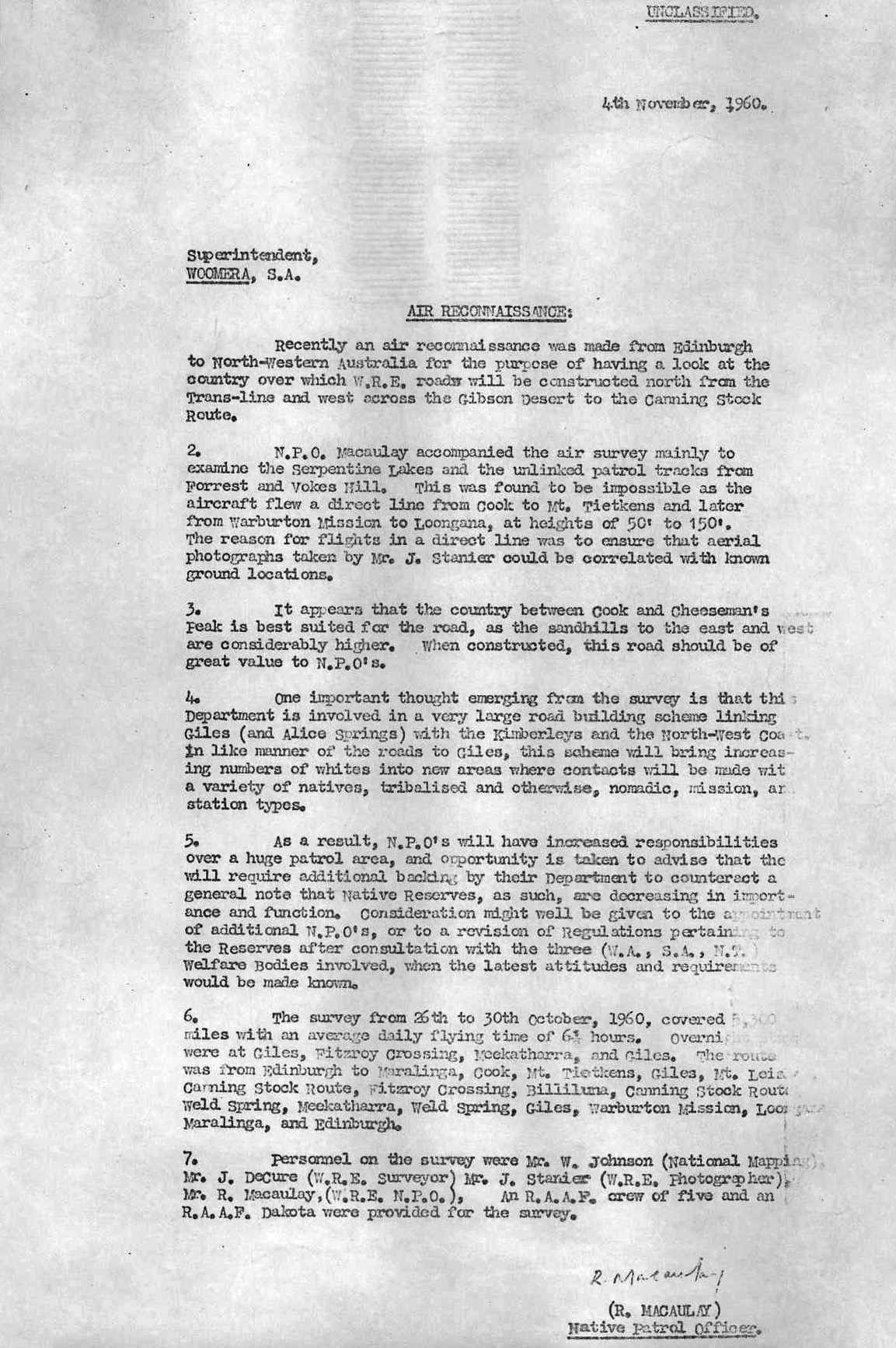
Nat Map search for Blue Streak rocket debris 1965
While working on the survey traverse from Young Range to Well 35 on the Canning Stock Route in July 1965, the Nat Map geodetic survey field party was requested to look for parts of a Blue Streak rocket that had come down to the north-west of Well 35. Technical Assistant Bob Goldsworthy (1939-1985) together with Field Assistants Kevin Snell and Bill Sutherland carried out the successful search using an AB120 series International 4-wheel drive utility. Their success was later acknowledged in a letter to the Director of National Mapping from the Secretary of the Department of National Development; a copy of which is provided below.
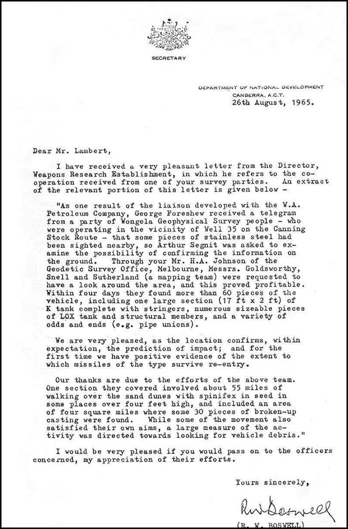
Copy of August 1965 letter to the Director of National Mapping from the Secretary of the Department of National Development.
Source: Ford (1979) on XNatmap web site.
Trevor Nossiter summary of Royal Australian Air Force service 1942-1946
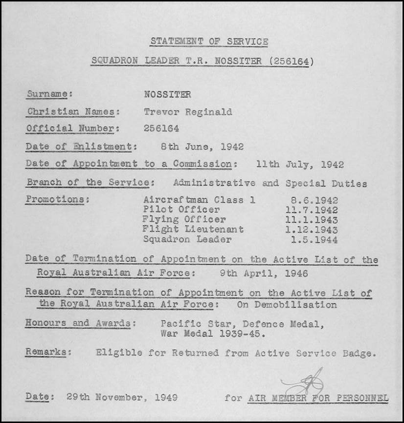
Source: National Archives of Australia (1939-1948).
Truscottt Airstrip Western Australia
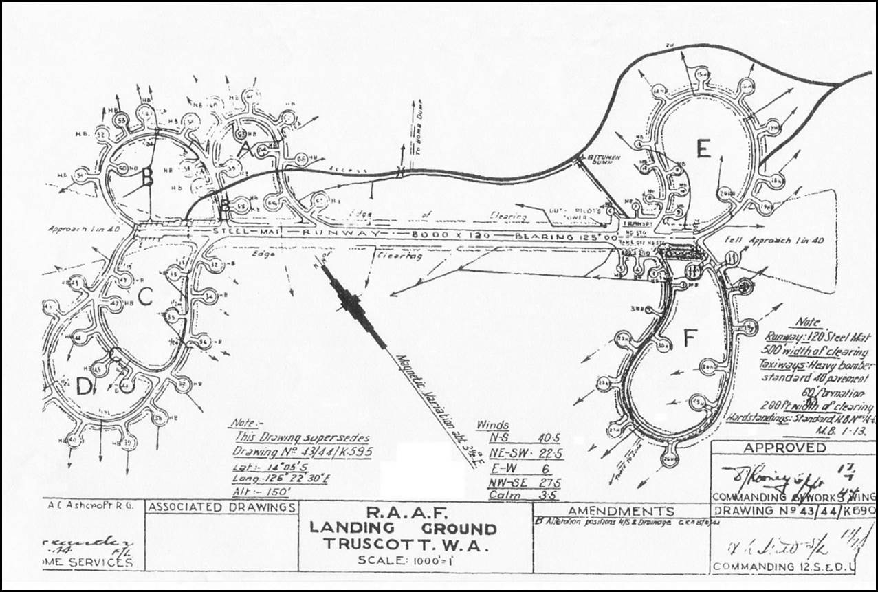
Truscottt Airstrip circa July 1945.
Royal Australian Air Force, Drawing No 43/44/K690, prepared by Aircraftman Ronald George Ashcroft.
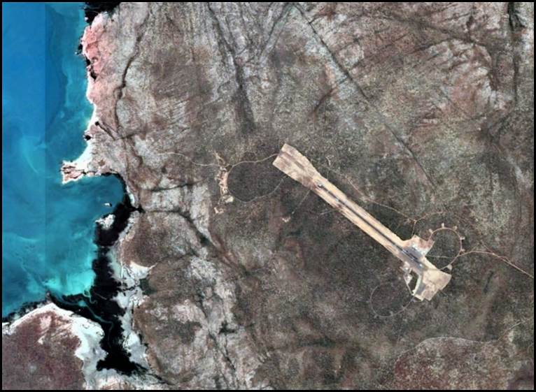
Truscott-Mungalalu Airport.
Google Earth satellite image 2022.
References
Anonymous (1918), State High Schools, Qualifying Examination, The Results, an article in the Examiner (Launceston), on Thursday 10 January 1918, page 7; accessed from the National Library of Australia’s Trove search service at: https://trove.nla.gov.au/newspaper/article/50961651
Anonymous (1944), Engineers on Air Strip South-West Pacific Front, a news article in The Age newspaper on Wednesday 20 September 1944, page 3; accessed from the National Library of Australia’s Trove search service at: https://trove.nla.gov.au/newspaper/article/205995417
Anonymous (undated), Trevor Reginald Nossiter 17 February 1906–16 December 1992; a family history item accessed from the Family Search web site of the The Church of Jesus Christ of Latter-day Saints at:
https://ancestors.familysearch.org/en/9WLK-QLC/trevor-reginald-nossiter-1906-1992
Anonymous (undated A), The MCG and World War II, an article in The RAM, the magazine by and for serving and ex-serving RAAF people and others, Volume 62, page 13 D; accessed from: https://www.radschool.org.au/magazines/Vol62/pdf/Page13.pdf
Australian Electoral Commission (various dates), Searches for Trevor Reginald Nossiter and family members on historical electoral rolls between 1903 and 1980; accessed from the Ancestry web site at : http://search.ancestry.com.au/search/
Beadell, Leonard (1965), The Final Reconnaissance, Chapter 12, pages 143‑154, in Too Long in the Bush; New Holland Publishers (Australia) Pty Ltd, Frenchs Forest NSW; ISBN 1 86436 719 9
Blair, Sandy; Helms, David; Ingledew, Fae; and Doyle, Helen (Context Pty Ltd project team), 2007, Victorian Water Supply Heritage Study, Volume 1: Thematic Environmental History, Final Report; prepared by Context Pty Ltd for Heritage Victoria; accessed from Heritage Victoria web site at: https://www.heritage.vic.gov.au/__data/assets/pdf_file/0016/61432/Vic_Water_Supply_study_Vol1_partA.pdf
Commonwealth of Australia (1950) Appointment of TR Nossiter to commission as Temporary Flight Lieutenant, Citizen Air Force, Air Force Reserve, Equipment Branch from 6 July 1950; promulgated in the Commonwealth of Australia Gazette, No.66, Thursday 2 November 1950, page 2784; accessed at: https://www.legislation.gov.au/content/HistoricGazettes1950
Commonwealth of Australia (1954), Department of Supply South Australia, promotion of Trevor Reginald Nossiter to Senior Reconnaissance Officer Third Division, Long Range Weapons Establishment, Research and Development Branch, Salisbury promulgated in the Commonwealth of Australia Gazette, No 40, 1 July 1954, page 1912; accessed at: https://www.legislation.gov.au/content/HistoricGazettes1954
Commonwealth of Australia (1969), Department of Supply notification of the retirement of Trevor Reginald Nossiter, Senior Reconnaissance Officer on 6 June 1969; promulgated in the Commonwealth of Australia Gazette, No. 70, 14 August 1969, page 4861; accessed at: https://www.legislation.gov.au/content/HistoricGazettes1969
Edwards William Howell (2000), MacDougall, Walter Batchelor (1907–1976), an article in the Australian Dictionary of Biography, National Centre of Biography, Australian National University, accessed from the Australian National University web site at: https://adb.anu.edu.au/biography/macdougall-walter-batchelor-10944/text19447
Ford, Reginald Arthur BEM (1979), The Division of National Mapping’s Part in the Geodetic Survey of Australia, in The Australian Surveyor, June, September and December 1979: Volume 29, No 6, pp. 375-427; Volume 29, No 7, pp. 465-536; Volume 29, No 8, pp. 581-638, ISSN 00050326, published by the Institution of Surveyors, Australia; accessed from XNatmap website at: http://www.xnatmap.org/adnm/ops/prog/rafgeosvy/index.htm
Johnson, Howard Angas MBE (1958), Reconnaissance Report on Proposed Geodetic Survey Mt Harvest to Carnegie Homestead June 1958; Division of National Mapping, Department of National Development, Melbourne; accessed from the XNatmap website at: http://www.xnatmap.org/adnm/docs/drtrds/HAJ%201958%20CARNEGIE%20RECON.htm
Lawrence, Thomas Fulton Coleman (1993), Boswell, Robert William McGregor (1911–1976), an entry on the Australian Dictionary of Biography, National Centre of Biography, Australian National University, accessed at: http://adb.anu.edu.au/biography/boswell-robert-william-mcgregor-9547
MacDougal, Walter Batchelor (1960), Air Reconnaissance, unpublished internal memorandum dated 4 November 1960, Weapons Research Establishment, Department of Supply, Woomera; accessed from XNatmap website at: http://www.xnatmap.org/adnm/docs/drtrds/airsvy%201960.jpg
Murray Irrigation (2020), Irrigation History; a section on the Murray Irrigation web site; accessed at: https://www.murrayirrigation.com.au/company/our-industry/irrigation-history/
National Archives of Australia (undated), Agency notes from advanced agency record search on Weapons Research Establishment, Salisbury (South Australia), agency number: CA 3039 (listing only); accessed from search on National Archives of Australia web site at: https://recordsearch.naa.gov.au
National Archives of Australia (undated A), Defence Research and the Anglo Australian Joint Project; accessed from the National Archives of Australia web site at: http://guides.naa.gov.au/records-about-south-australia/chapter15/15.4.aspx
National Archives of Australia (1939-1948), Nossiter, Trevor Reginald, Royal Australian Air Force World War II officer’s service record; Citation: NAA: A9300, NOSSITER T R; Item barcode: 5244322; accessed from search of RAAF officers personnel files 1921-1948, Series A9300; on National Archives of Australia web site at: http://www.naa.gov.au/collection/explore/defence/service-records/raaf.aspx
Royal Australian Air Force Historical Section (1995), Units of the Royal Australian Air Force: A Concise History, Volume 9 Ancillary Units; Australian Government Publishing Service, Canberra, ISBN 0644428023; accessed from Royal Australian Air Force web site at: http://airpower.airforce.gov.au/APDC/media/PDF-Files/Air%20Force%20Publications/AF30-Units-of-the-RAAF-Volume-9-Ancillary-Units.pdf
Smith, Ailie (2001), Victorian State Rivers and Water Supply Commission (1905-1984), an entry in the Encyclopedia of Australian Science; accessed from the Encyclopedia of Australian Science web site at: http://www.eoas.info/biogs/A001520b.htm
Smith, Robert Ross (1953), The Approach to the Philippines, United States Army in World War II: The War in the Pacific, Washington DC, United States Army Center of Military History, page 476, Map 20 (drawn by H Damon); accessed from Wikipedia web site at: https://en.wikipedia.org/wiki/Battle_of_Morotai#/media/File:Morotai_landings_15_September_1944.jpg